Maps of Kalderesh

Kalderesh is a large island (one of the Six Islands) off the west coast of Brundonica. It measures about 1,604 km by 829 km, has a surface area of 738,000 km2 and is oriented approximately north–south.
The northernmost point is Friar’s Point (+14°04’43”). The southern tip lies near Spider Island (+04°27’06’’). Cape Phegnia (02h44m03s ) marks the westernmost extent while Cape Fortune (03h03m17s) marks the easternmost point. The 03h meridian passes very close to Camfor, the capital city.
As an ocean-bound nation, it is surrounded to the north by the Agopean Sea, to the east by the Shining Sea, to the south by the Dolphin Sea, and to the west by the Sea of Cobras. To its north (c. 600 km) lies the island of Agopea, to the east (c. 930 km) is the mainland of Brundonica, south (c. 530 km) is the island of Dojka, and west (c. 185 km) is the island of Cikeski.
-
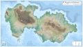 The Kingdom of Kalderesh
 -
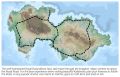 Major road network of Kalderesh, the Royal Road
 -
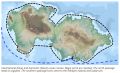 International and domestic ocean routes around Kalderesh


--Download links-- Map of Kalderesh MediaWiki 1px = 150ft v11-Db 4k.jpg 1px = 150ft v11-Db 8k.jpg 1px = 150ft v11-Db Full.jpg